Earthquake of magnitude 4.6 - 15 km WSW of Dompu, Indonesia
Earthquake of magnitude 5.7 - South Indian Ocean
Earthquake of magnitude 4.7 - South Indian Ocean
Earthquake of magnitude 4.9 - 159 km S of ‘Ohonua, Tonga
Earthquake of magnitude 4.7 - 1 km ESE of Nueva Italia de Ruiz, Mexico
Earthquake of magnitude 4.6 - 27 km NE of Ambunti, Papua New Guinea
A 6.1 magnitude earthquake occurred 36.04mi NNE of Eloúnda, Greece.
Earthquake of magnitude 6.1 - 58 km NNE of Eloúnda, Greece
VEGETATION FIRE - Tin Mine Rd. X La Sierra Ave. in El Cerrito. Firefighters are on scene of a 20-acre vegetation fire at the above location and have stopped the forward rate of spread. Aircraft was requested to assist with ground efforts
Earthquake of magnitude 5.2 - South Sandwich Islands region
Earthquake of magnitude 4.7 - 269 km NE of Saipan, Northern Mariana Islands
Earthquake of magnitude 5.2 - South Sandwich Islands region
Earthquake of magnitude 4.6 - 122 km S of Kokopo, Papua New Guinea
Earthquake of magnitude 4.6 - 52 km SW of Hihifo, Tonga
Earthquake of magnitude 4.6 - 84 km NW of Fef, Indonesia
Earthquake of magnitude 4.6 - Izu Islands, Japan region
Earthquake of magnitude 4.7 - Kermadec Islands, New Zealand
Cedar Fire burning near Oracle
Earthquake of magnitude 5.5 - 242 km SSE of Ushuaia, Argentina
Earthquake of magnitude 4.6 - south of the Fiji Islands
Earthquake of magnitude 5.0 - Pacific-Antarctic Ridge
Earthquake of magnitude 4.6 - 226 km SSE of Ushuaia, Argentina
Earthquake of magnitude 4.6 - Fiji region
Earthquake of magnitude 4.9 - Mauritius - Reunion region
2.5 magnitude earthquake. 9 mi from Muscoy, CA, United States
Earthquake of magnitude 4.9 - central Mid-Atlantic Ridge
 6 Monat zuvor
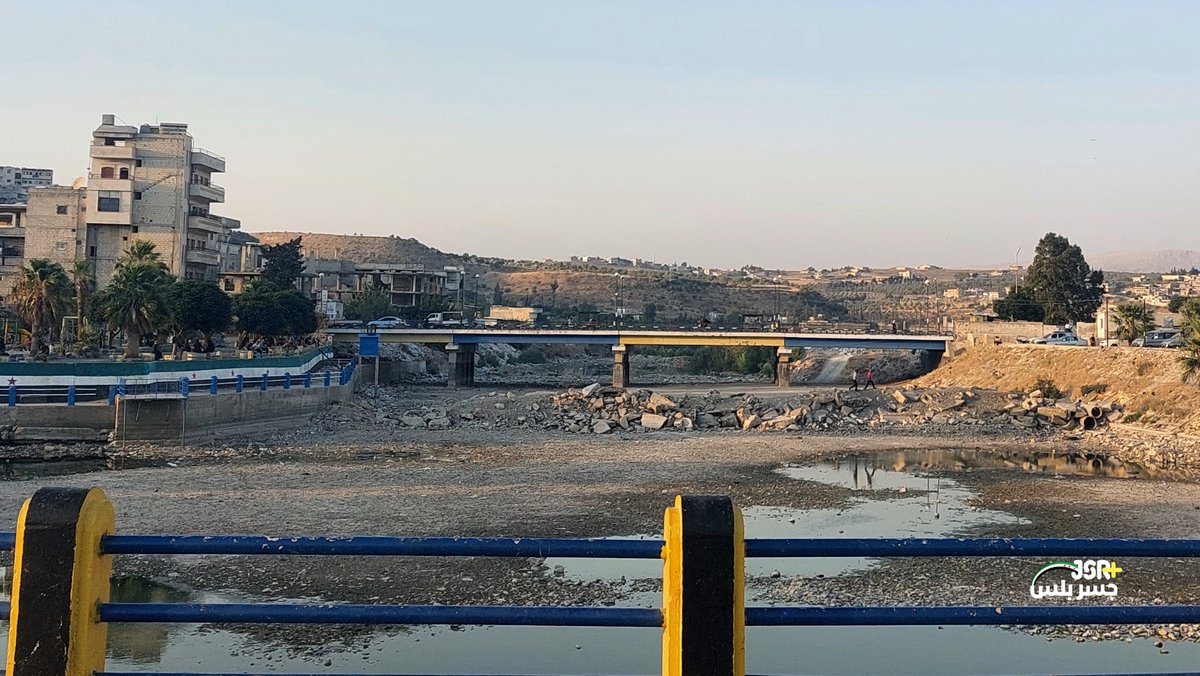
Syrien erlebt eine der schlimmsten Dürren seiner jüngeren Geschichte. In Damaskus ist der Wasserstand der Ain-Fijah-Quelle deutlich gesunken und reicht nicht mehr aus, um den Bedarf der Provinz zu decken. Dies führt in vielen Gebieten zu häufigen Wasserausfällen. Ein Notfallplan wurde aktiviert, der die Nutzung möglichst vieler Brunnen parallel zur Quelle vorsieht. Im Norden leidet auch der Orontes unter niedrigem Wasserstand, was sowohl den Zugang zu Wasser als auch die landwirtschaftliche Bewässerung in mehreren Gebieten gefährdet.
Earthquake of magnitude 6.6 - 116 km NE of Angoram, Papua New Guinea
Earthquake of magnitude 6.4 - 81 km ENE of Angoram, Papua New Guinea
Earthquake of magnitude 6.6 - 111 km NE of Angoram, Papua New Guinea