2 months ago
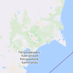
Earthquake of magnitude 5.0 - 94 km E of Petropavlovsk-Kamchatsky, Russia
2 months ago Earthquake of magnitude 5.1 - southern Mid-Atlantic Ridge
 2 months ago
Crews have been dispatched to a vegetation fire in the area of the 3000 block of Sage Road in Fallbrook. Crews are in the area with nothing showing. Crews are investigating the area
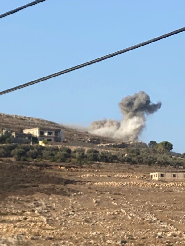
2 months ago Multiple fire crews are battling a newly-sparked wildfire, called the Horton Fire, in the Tonto and Apache Sitgreaves National Forests
2 months ago Earthquake of magnitude 4.7 - 172 km WSW of Riverton, New Zealand
2 months ago Earthquake of magnitude 5.9 - 136 km W of Neiafu, Tonga
2 months ago Earthquake of magnitude 5.0 - 6 km N of Santiago Tepextla, Mexico
2 months ago 2.8 magnitude earthquake. 26 mi from Ferndale, CA, UnitedStates
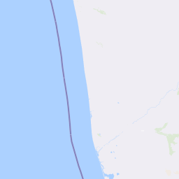
2 months ago Notable quake, preliminary info: M 5.2 - 73 km WNW of Petrolia, CA
2 months ago 5.3 magnitude earthquake. 47 mi from Ferndale, CA, UnitedStates
2 months ago Earthquake of magnitude 5.3 - 73 km WNW of Petrolia, CA
2 months ago Earthquake of magnitude 5.4 - 156 km WSW of Ferndale, California
2 months ago Earthquake of magnitude 4.6 - South Sandwich Islands region
2 months ago Earthquake of magnitude 4.8 - 57 km NE of Pototano, Indonesia
2 months ago Earthquake of magnitude 5.2 - 45 km SE of Gizo, Solomon Islands
2 months ago Earthquake of magnitude 5.1 - Mid-Indian Ridge
2 months ago Earthquake of magnitude 4.9 - south of the Kermadec Islands
2 months ago Earthquake of magnitude 5.3 - 122 km NW of Ternate, Indonesia
2 months ago Earthquake of magnitude 4.6 - 101 km NE of Kainantu, Papua New Guinea
2 months ago Earthquake of magnitude 4.7 - 77 km ESE of Isen, Japan
2 months ago Earthquake of magnitude 4.9 - 98 km SSW of Uyuni, Bolivia
2 months ago Earthquake of magnitude 4.8 - west of Macquarie Island
2 months ago Earthquake of magnitude 4.7 - west of Macquarie Island
2 months ago Earthquake of magnitude 5.2 - 78 km E of Wainui, New Zealand
2 months ago Franklin Fire activity remained minimal with no significant fire growth today. The fire remains at 4,037 acres burned and containment increased to 32%.All evacuation orders have been reduced to warnings as of Dec. 13Access to evacuation warning areas is still restricted
2 months ago Earthquake of magnitude 4.8 - 170 km ESE of Labuha, Indonesia
2 months ago Earthquake of magnitude 4.6 - Volcano Islands, Japan region
2 months ago Earthquake of magnitude 5.3 - South Sandwich Islands region
2 months ago Earthquake of magnitude 4.6 - 139 km SSE of Lata, Solomon Islands
2 months ago Earthquake of magnitude 6.4 - 41 km ESE of Molina, Chile
Climate and Ecology latest news on live map. Climate Strike map
Colors on the map
Icons
 Los accidentes de tráfico, coches
  Artillería1, MLR
 Aviones, chorros
 Helicópteros
  Campos,carpas
 Capturado
 Muerto
 Ataques punzantes
  Fuegos
 Herir/medicina
 Bomba de fuego
  Policía
  Tiroteo
  Discurso , estado
 La parada, la barricada
  Tanques, comités, vehículos blindados
  Los matones, la gente con máscaras
  Armas nucleares, material radioactivo
  El barco, buque de guerra
 Gas, chemical weapons
 Aviones teledirigidos, robots
 La manifestación , prostestas, población, multitudes
  Rehenes y refugiados
  Ninguna conexión , interferencia, radar
 Rifle pistola, hombres armados
  Explosión , ráfagas
  Bombardeo
 Camiones
  Piratas informáticos, ordenadores
  Imagen (foto)
 Comida
 Dinero
 Prensa
 Teléfono
  Fuerte
 Video
Video  Destrucción
  Minas, AEI
 Grúa , construcción
  Ferrocarril
  Casa
Casa Antiaérea , SAM
 No hay agua
  Cohete
 Submarino
 Twitter
  Facebook
  Electricidad, apagón
  Peligro biológico
  Naturaleza , desastres
  Acciones
 El transporte o el avión civil
 Operación de rescate
  Recurso natural
 Móvil , aplicaciones
  Drogas
 Terremoto
  Inundaciones
  Tsunami
  Animales, la vida silvestre
  Deportes
 Mapa
Mapa Volcán
  Nieve
Nieve  Pollution
 Manpads
 Corrupción
 Satellite
 Alcohol
 Arrested
 Sun
Sun Bus
Bus Animals: Cat
 Animals: Dog
 Stocks Down
 Animals: Snake
 ATGM
ATGM Animals: Panda(rare animals)
 Animals: Horse
 Animals: Cow
 Animals: Lion
 Animals: Shark
 Animals: Wolf
 Supply
 Flares
 Animals: Bear
 Machine Gun
 Stun grenade
  Airplanes: light plane
 Motobike
 Balloon
 Bulldozer
 Cruise Missile
 FPV drone
 Map Change Event
 Missile Airborne
 Quadcopter(Mavic)
 Large explosive drone(Shahed)
 Tractor
 Tunnel
 Air Alert
 Aerostat, High-Altitude balloon
¡Atención! Todos los eventos y áreas de control en el mapa están geolocalizados aproximadamente.